Agroecological zone of Bangladesh/Physiographic units of Bangladesh
Agroecological zone
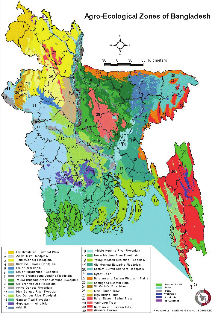
Agroecological zone is a zone which has a unique combination of physiographic, soil, hydrological and agroclimatic characteristics. Thirty agroecological zones (AEZ), 88 sub-zones (sub-regions) and 535 agroecological units have been identified in Bangladesh on the basis of important differences in physiography, soil, hydrological and agroclimatic characteristics. Agroecological zoning helps classify regions where a particular crop may or may not be grown.
Physiography
Physiography is the combination of geological material in which, a particular kind of soils have formed and the landscape on which they occur. It is the primary element in defining and delineating the agroecological regions of Bangladesh. Bangladesh can be divided into three broad physiographic regions. The percentage composition of these three physiographic regions are as follows:
Physiographic region and percentage
1. Northern and Eastern Tertiary hills 12%
2. Pleistocene terraces 8%
3. Recent flood plains 80%
Physiographic units of Bangladesh
1. Recent floodplains
a. Old Himalayan Piedmont Plain
b. Tista Floodplain
i. Active Tista Floodplain
ii. Tista Meander Floodplain
c. Karatoya-Bangali Floodplain
d. Lower Atrai Basin
e. Lower Punarbhaba Floodplain fo Brahmaputra Floodplain
i. Active Brahmaputra-Jamuna Floodplain
ii. Young Brahmaputra and Jamuna Floodplain
iii. Old Buahmaputra Floodplain
g. Ganges River Floodplain
i. Active Ganges Floodplain
ii. High Ganges River Floodplain
iii. Low Ganges River Floodplain
h. Ganges Tidal Floodplain
i Ganges Tidal Floodplain (Non-Saline)
ii. Ganges Tidal Floodplain (Saline)
iii. Ganges Tidal Floodplain (Sunderbans)
i. Gopalganj-Khulna Bils
j. Arial Bil
k. Meghna River Floodplain
i. Middle Meghna River Floodplain
ii. Lower Meghna River Floodplain
l. Meghna Estuarine Floodplain
i. Young Meghna Estuarine Floodplain (Non-Saline)
ii. Young Meghna Estuarine Floodplain (Saline)
iii. Old Meghna Estuarine Floodplain
m. Surma-Kushiyara Floodplain
i. Eastern Surma-Kushiyara Floodplain
ii. Sylhet Basin n. Northern and Eastern Piedmont Plains
o. Chittagong Coastal Plain
p. St. Martins Coral Island
2. Pleistocene terrace
q. Barind Tract
i. Level Barind Tract
ii. North-eastern Barind Tract
iii. High Barind Tract
r. Madhupur Tract
3. Tertiary hills
s. Northern and Eastern Hills
i. High Hill Ranges
ii. Low Hills
t. Akhaura Terrace
References: https://banglapedia.org, https://www.researchgate.net/